City of stolen kere: what Kempegowda built and what Bengaluru built over it
Last revised May 2026. A long-read companion to the live dashboard and facts page. Dashboard - Facts
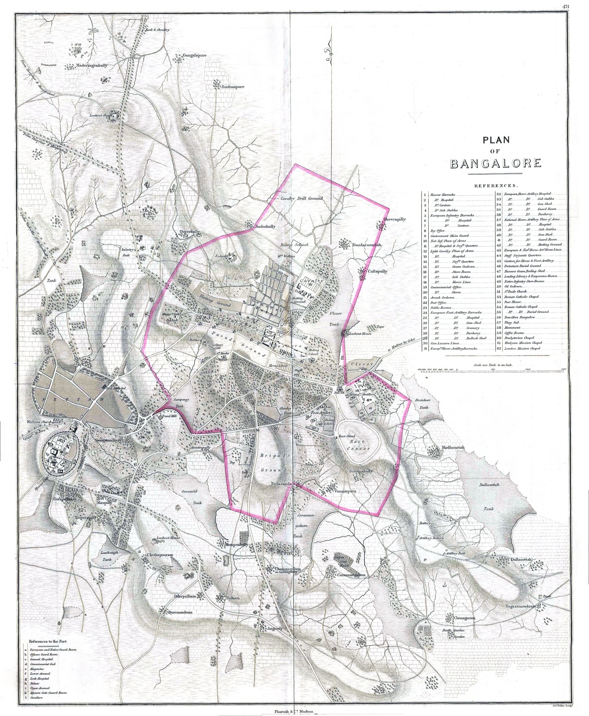
Bengaluru sits on a ridge, not a river. Its founder in 1537, Kempe Gowda I, had no Vaigai or Cooum to dam, so he built lakes instead - kere (ಕೆರೆ) in Kannada, earthen bunds across the gentlest slope of each valley, daisy-chained so the overflow from the upper kere filled the next one down. Nineteenth-century gazetteers counted close to three hundred kere in what is now BBMP. Today, by the most generous count, about a third still hold water; by a stricter count, fewer than twenty are in something the Indian Institute of Science is willing to call good condition. The oldest kere this city had - Dharmambudhi - is a bus stand. The kere the founder himself built - Kempambudhi - is now a sewage drain. The first thing every visitor to Bengaluru ever did - look at a kere - is now harder to do here than in most villages in Karnataka.
Kere: the tank builders, 1537-1799
Bengaluru did not have a river. It had a chieftain whose mother told him in Kannada to build lakes and plant trees, and a Vijayanagar emperor who gave him permission to do it.
Kempe Gowda I (1513-1569) was a vassal of the Vijayanagara empire, ruling the Yelahanka nadu as the head of the Morasu Vokkaliga community. The empire was at its imperial height under Krishnadevaraya; Yelahanka was a productive but unremarkable hill-country tract about ten kilometres north of a slightly larger ridge plateau that the locals already called Bengaluru. An inscription at Dasarahalli, on the way down from Yelahanka into the plateau, records the year in which the emperor Achyutaraya granted Kempe Gowda permission to build a new town there: 1532. Construction took five years. A founding ceremony at Doddapete junction - today the intersection of Avenue Road and Chickpete, the centre of the original walled Pete (ಪೇಟೆ) - laid down four roads in the four cardinal directions, anchored by four watchtowers, and on an auspicious moment fixed by an astrologer Kempe Gowda yoked a pair of bullocks to a plough and turned the first furrow. The year was 1537. That ploughed line is the founding date Karnataka still celebrates.
He did not just build a town. He built it together with its water. The locally remembered version is that his mother instructed him in a single Kannada sentence: keregalum kattu, marangalum nedu- build lakes, plant trees. He took it literally. Within his lifetime he had built the kere that bears his family deity Kempamma's name - Kempambudhi - alongside Dharmambudhi (whose surplus drained toward what is now Majestic), Sampangi (which gave its name to the road that ran around it), and several smaller ponds in the Pete. Three valleys ran off the ridge the city sat on; he aligned the kere along all three. Each one was a low earthen bund across the gentlest slope of the valley, fronted by a stone kalyani(ಕಲ್ಯಾಣಿ) where temple priests drew water for ritual, with a sluice (or sometimes a notched spillway) controlling release. The overflow from the upper kere fed the next one downstream. By Kempe Gowda's grandson's time, in the early seventeenth century, the three valleys held a working cascade of dozens of interconnected kere whose water irrigated paddy, washed clothes, recharged the open wells in every pete neighbourhood, and supplied tank-fed temple festivals.
“The lakes of Bengaluru are not natural lakes. They are tanks - made by damming the flow of water, fed by the rain, designed to feed each other.”
Two more political eras built on what Kempe Gowda started. The Maratha governor Shahaji Bhonsle ruled Bengaluru from 1638; his son Shivaji was born here. The Wadiyars of Mysore took it in 1689, kept it for seventy years, then lost it to Hyder Ali in 1761. Hyder Ali and his son Tipu Sultan - who together ruled Bengaluru for the last four decades of the eighteenth century - built a stone fort, expanded the cantonment-era armaments, and laid out the famous Lal Bagh botanical garden (literally the red garden, after its red rose plantings). They did not invent the kere system. They inherited and maintained it. The maintenance was done at the village level through a tax-supported obligation that the colonial gazetteers later called shisthu kattu - tank repair was a community duty enforced by the state and tied to land revenue. Bunds were patched after every monsoon; sluices were de-silted; the chains stayed connected. The kere did not maintain themselves. Nobody pretended they did. The eighteenth-century historian Mark Wilks, writing of the Mysore wars, recorded the kere as ordinary working infrastructure in the landscape - hardly worth narrating, which is itself the highest compliment a piece of working infrastructure can receive.
In May 1799 the British and the Marathas together stormed Tipu Sultan's capital at Srirangapatna, fifty miles south-west of Bengaluru. Tipu fell at the breach. The British East India Company took the Mysore kingdom under indirect rule. Bengaluru, the old Pete, was technically restored to the Wadiyar dynasty under British paramountcy. What the British took directly was the cantonment.
The Cantonment tap, 1809-1947
When British military health needed water, the kere stopped being the city's water and became the natives' water. Two cities, two pipes.
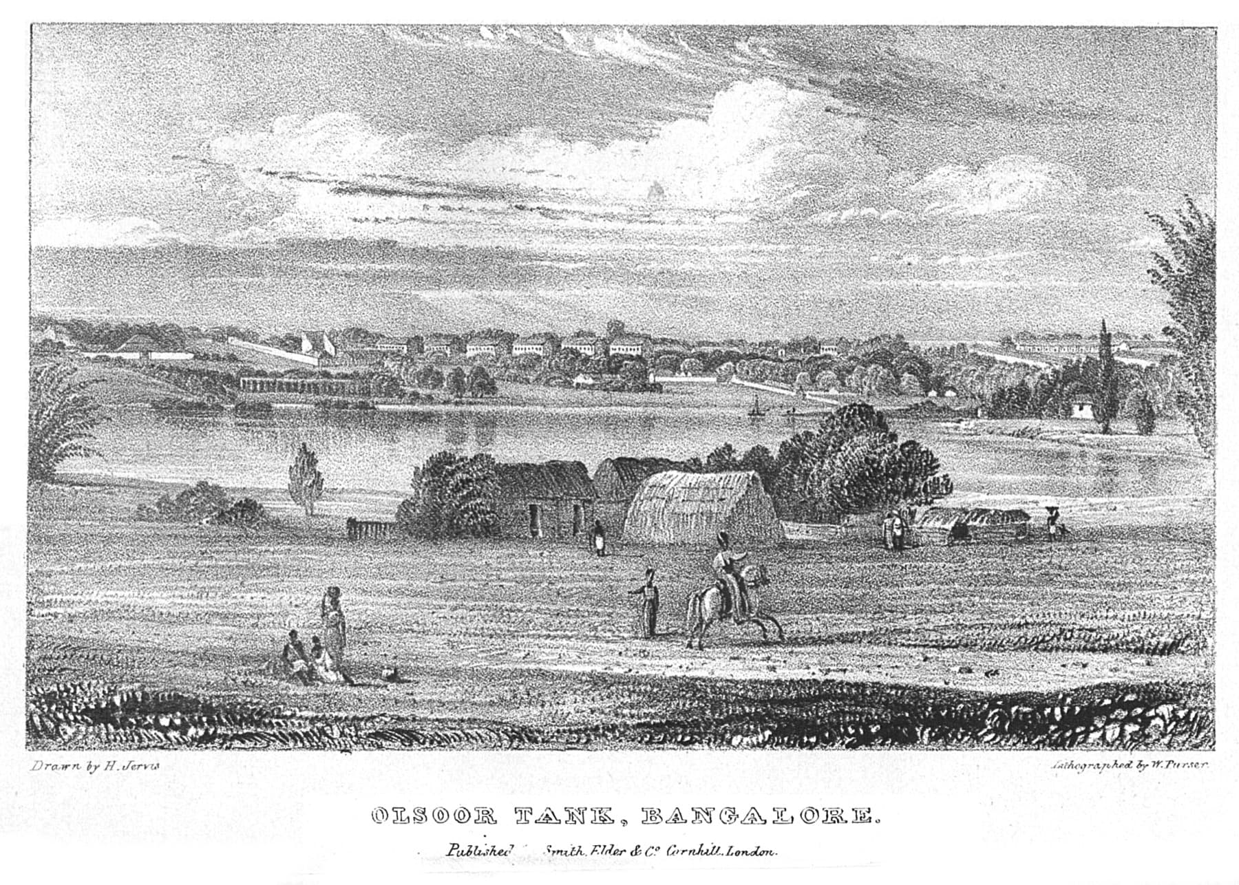
In 1809 the East India Company, finding the swampy islets of Srirangapatna unfit for the long-term health of European troops, moved the resident garrison north to the higher, drier Bengaluru plateau. By 1811 a fifty-thousand-strong cantonment had been laid out east of the old Pete around Halsoor Lake. Two cities now coexisted under one name: Bangalore Civil and Military Station - the Cantonment, administered directly by the British Resident - and Bangalore Pete, the older walled town, which remained nominally under the Mysore Durbar at the Wadiyar palace. The line between them ran roughly along what is now MG Road. The Cantonment populated itself with Tamil-speaking mess servants, English officers, Anglo-Indian railway clerks, and an Irish regimental population. The Pete remained Kannada-speaking. Both cities used the kere. The Cantonment, for its first half-century, drew its water from Halsoor lake, from open wells, and from the seasonal Vrishabhavathi runoff.
The break came with cholera. The Cambridge Urban History article by James Heitzman and others titled Flows and fixes: water, disease and housing in Bangalore, 1860-1915 (Urban History, 2021) traces the sequence in granular detail. After repeated cholera and typhoid outbreaks in the 1870s and 1880s, the colonial Sanitary Commissioner for Mysore concluded that British troops could not safely continue to drink from the same kere as the native population. A separate piped water supply was needed - one fed not by the contaminated tanks at the edge of the Cantonment but by an impoundment somewhere upstream and uphill, where catchment land could be cleared of human settlement and the water bacterially clean. The candidate was the Arkavathi River, eighteen miles north-west of the city. The dam was built at Hesaraghatta village, completed in 1894, and named the Chamarajendra Water Works after the then-king Chamarajendra Wadiyar IX. The project was driven and largely financed by Sir K. Seshadri Iyer, Dewan of Mysore from 1883 to 1901, who is the only Indian official formally credited with the scheme. It was the first piped water supply ever delivered to any Indian city by mechanised pumping rather than gravity.
“Hesaraghatta was not a substitute for the kere. It was a parallel water supply for the population that could no longer be asked to share a tank with the population that already had one.”
The point of Hesaraghatta is not that it gave Bengaluru piped water. It is what it did to the kere. From 1894 onward the official water supply, the one the Cantonment trusted and the colonial Sanitary Commissioner certified, came from somewhere else. The kere were no longer central to the European population's water need. They became the natives' water - and, slowly, the city's wastewater. The colonial-era institution that had maintained the cascade, shisthu kattu, was not exactly abolished; it was quietly stopped being enforced. Tanks that no one was responsible for began to silt. The kere closest to the Cantonment - Halsoor, Sampangi, Akkithimmanahalli - became increasingly polluted as colonial-era industry and small settlements drained into them without the maintenance cycle that had kept them clean.
By 1933 Hesaraghatta itself was no longer enough. A second, larger reservoir was built downstream on the same Arkavathi river, at Tippagondanahalli, and named Chamaraja Sagara after the dynasty's long-serving monarch. TG Halli, as it came to be called in BWSSB shorthand, became the city's primary surface-water supply from the 1930s into the 1980s. Both Hesaraghatta and TG Halli would later die the same way: the Arkavathi catchment got built over, the monsoon stopped recharging them, and untreated sewage from the upstream layout colonies destroyed the water quality of what was left. By the time BWSSB was constituted as a statutory board in 1964 to professionalise the city's water supply, the Arkavathi reservoirs were already losing yield. The Cantonment-Pete water arithmetic of the 1890s - there are too many of them and not enough water, so build a separate supply for the ones who matter - was about to be repeated at a larger scale, with a different river.
Cauvery ninety kilometres away, 1947-2010
Bengaluru stopped being a city with lakes and became a city with a pipe coming uphill from a river it never saw.
The Cauvery does not flow past Bengaluru. The river runs ninety-five kilometres south-east of the city, draining a watershed Bengaluru is not in. By the late 1960s the Arkavathi was visibly failing; the BBMP's precursor, the City Municipal Council, was already rationing supply. The Government of Karnataka petitioned the central government for an allocation from the Cauvery, and in December 1974 the first stage of the Cauvery Water Supply Scheme was commissioned, lifting 135 million litres per day from an intake at T.K. Halli on the Cauvery, treating it at a riverside plant, and pumping it uphill against five hundred metres of elevation through three pumping stations - T.K. Halli to Harohalli to Tataguni - and into the city. It was, and remains, one of the most energy-intensive municipal water supplies in the world. The Bangalore Water Supply and Sewerage Board (BWSSB), constituted by the Karnataka legislature ten years earlier in 1964, owned and ran the pipe. By the salient-features table of the JICA Bengaluru Water Supply and Sewerage Project Phase 3 Final Report (2017), roughly seventy-five per cent of BWSSB's annual operating revenue is consumed by electricity for that pumping.
The pipe came in stages. Stage I in 1974 added 135 MLD; Stage II in 1982, another 135 MLD; Stage III in 1992, 270 MLD; Stage IV Phase 1 in 2002, 270 MLD; Stage IV Phase 2 in 2012, 500 MLD. The total Cauvery WTP capacity at Bengaluru, by 2012, was 1,310 MLD - up from zero forty years earlier, and two and a half times what Hesaraghatta plus TG Halli had ever managed. The official monthly-maximum supply, per the JICA tables, was 1,450 MLD. The city's population had grown from roughly two million in 1974 to over eight million by 2010. Per-capita supply hovered around 146 litres per person per day on paper, against the CPHEEO design standard of 150 LPCD for a metropolitan city. What actually reached consumer taps, per the same JICA report, was seventy-six litres. The forty-eight per cent gap - what the engineering literature politely calls non-revenue water, the rest of us call leaks and theft - was higher than any comparable Indian city.
“A 466 per cent increase in built-up area between 1973 and 2007 was accompanied by a 58 per cent decline in wetland area in Greater Bangalore.”
Meanwhile, the kere died. Not all at once. The mechanism was uniform: a kere, no longer maintained because no one was legally responsible for it, silted and shrank. Once it was small enough to look like waste ground, the city built on it. Dharmambudhi - Kempe Gowda's second-built kere - was drained for the Kempegowda Bus Station (Majestic). Sampangi went under the Sri Kanteerava Stadium. Karanji Anjaneya tank became the Bishop Cotton Boys School ground. Akkithimmanahalli tank is a hockey stadium. Sankey, named after the British engineer who designed it, survives as a decorative water body in central Malleshwaram. The Indian Institute of Science's Centre for Ecological Sciences, led by T.V. Ramachandra and Sudhira H.S., surveyed 105 kere across Greater Bangalore in the late 2000s and concluded that only four were in good condition - the rest were either covered in macrophyte mats, choked with solid waste, or holding little to no water. Using Landsat data they documented a 466 per cent increase in built-up area between 1973 and 2007 alongside a 58 per cent decline in wetland area. The kere chains that Kempe Gowda had laid along the three valleys were broken; the storm-water drains (rajakaluves) that had once linked one kere to the next had been narrowed, paved over, or built up against.
The most-studied single case is Agara. R. D'Souza and Harini Nagendra's 2011 paper in Environmental Management - Changes in Public Commons as a Consequence of Urbanization: The Agara Lake in Bangalore, India- traces what happened in four decades to one ninety-acre kere south of the original Pete. Until the 1970s, Agara was a working agricultural commons: fishers netted from a wooden landing on its eastern shore, dhobis washed clothes on the western, paddy farmers drew water by chain pump, and the surrounding villagers grazed cattle on its bunds. By the late 2000s, the agriculture was gone, the fishers had been moved out, the surrounding wards were upper middle class apartment blocks, and the kere had been re-classified as a recreation site managed by the Lake Development Authority. Community management had been replaced by state management. The visible improvement - jogging tracks, fencing, no more open sewage discharge - had come at the cost of the working uses that had given the kere its meaning. Nagendra's 2016 book Nature in the City documents the same pattern across all Bengaluru kere: the ones that survived survived as amenities, not as infrastructure.
Foam, fire, and the day the tap almost ran dry, 2010-2026
By the time the lakes started burning, the city was already running on tankers.
On 16 May 2015 the foam on the surface of Bellandur Lake - the city's largest, three hundred and seventeen hectares, fed by the entire Koramangala-Challaghatta valley sewerage system - caught fire. The foam rose past the height of the adjacent four-lane outer ring road. Passing motorists photographed flames burning at the lake-air interface above a floating raft of detergent-and-sewage scum. The fires recurred in 2017, in February 2018 (one fire burned for over thirty hours), and in 2021. The toxic foam events - foam spilling onto adjacent streets in shoulder-high drifts - recurred several times a year through the same period. Bellandur is downstream of the K&C Valley STPs whose combined design capacity is two hundred and forty-eight MLD; the actual untreated sewage volume that reaches the lake when those plants are over capacity or off-line, by various estimates, is between four and five hundred MLD - more sewage per day than the original lake's design throughput could plausibly hold.
The 2015 fire was the trigger for the case Forward Foundation v State of Karnataka at the National Green Tribunal. The petitioners - a Bengaluru-based environmental trust - documented the upstream rajakaluvesfeeding Bellandur, the apartment-block encroachments on the storm-drain network, and the buffer-zone violations along the lake's edges. The NGT's 2018 order required the Karnataka government to set aside Rs 500 crore for Bellandur revival and to enforce a 75-metre buffer zone (later modified to 30 metres at the perimeter, 50 metres for storm-water drains, 25 metres for canals). The order is widely cited as a turning point in Indian environmental jurisprudence - the first time an NGT bench explicitly held that a state government's failure to maintain a hydraulic system counted as an environmental violation in itself. The Bellandur fires have subsided since 2021. The sewage has not.
“Bengaluru ranks second after Cape Town among eleven global cities likely to run out of drinking water in the near future.”
In early 2018, a BBC feature - prompted by the same year's Cape Town Day Zero scare and a UN projections briefing - named Bengaluru as the city most at risk of going dry after Cape Town. The framing was contested in Karnataka but the underlying numbers held: BWSSB's 1,310 MLD Cauvery WTP capacity, against a JICA-projected 2034 demand of 2,608 MLD across Bengaluru BBMP plus the eight ULBs plus the 110 newly-merged villages, opened a structural ~1,000 MLD gap that could not be closed without the as-yet-uncommissioned Cauvery Stage V. Households filled the gap with private borewells - the WELL Labs Bengaluru Urban Water Balance Report (2021 data) estimates the city's groundwater dependence at 1,392 MLD, above the ~800 MLD the BWSSB-commissioned IISc Groundwater Outlook (2024-25) reads as actual extraction - and with private tanker water. The OpenCity Bengaluru Tanker Water Surveys captured what households actually paid: the median price per tanker load rose from Rs 510 in 2015 to Rs 800 in 2019 to Rs 1,300 in 2024. Of 160 apartment communities surveyed in 2024, 95.6 per cent reported relying on private tanker water; 90 per cent reported BWSSB supply had worsened year-on-year; 69 per cent reported ordering tanker water more often than the previous quarter. The Bellandur fires made Bengaluru's water crisis legible internationally. The tanker price made it legible at the household kitchen door.
Two later interventions are the closest the city has come to structural relief. On 16 October 2024, Cauvery Stage V was commissioned at T.K. Halli, with a design capacity of 775 MLD aimed at covering the 110 newly-merged villages and the eight ULBs that BBMP absorbed in 2007. By February 2026, per The Ken's May 2026 series Bengaluru doesn't have a water problem, actual delivery had reached approximately 400 MLD - just over half of design - because the last-mile distribution infrastructure in the merged villages was incomplete. And in parallel, BWSSB partnered with the French utility operator SUEZ on the country's largest indirect-potable-reuse pilot: the 1933-vintage TG Halli reservoir, defunct as a freshwater source for thirty years, is being repurposed to receive 110 MLD of tertiary-treated sewage that, after blending and residence time, becomes raw water for the upstream Cauvery WTP system. The first surviving piped supply system in Bengaluru is being reborn as the closing of the city's sewerage loop.
On 15 May 2025, the BBMP was dissolved by Karnataka Act 36 of 2025 and replaced by the Greater Bengaluru Authority (GBA), an umbrella body composed of five new City Corporations (Central, East, West, North, South) covering 369 wards. The final delimitation was notified on 19 November 2025, with name changes added 1 December 2025. The new geography inherits BWSSB's water arithmetic unchanged. The 65 BBMP wards that the BWSSB-commissioned IISc Groundwater Outlook of Bengaluru City (April 2025) had named as critically over-extracted - Hebbal, Yelahanka, KR Puram, Koramangala, Vijayanagar, Kengeri, Nagarbhavi, Chamarajpet among them - are still over-extracted under whichever ward number the GBA has now assigned them.
What is consistent through the four-century arc is that Bengaluru has always had to manufacture its water. There was no river. Kempe Gowda built the kere because he had to. K. Seshadri Iyer built Hesaraghatta because the cholera deaths had become embarrassing. BWSSB built Cauvery Stage I through V because the Arkavathi had been used up. What is different in 2026 is that the manufactured supply is inadequate to a city that grew faster than the engineering schedule. The kere - the original manufactured supply - are still there, mostly. Two hundred and seventy of them survive, on the GBA's most recent inventory, if you count generously. About a third of those survive as water. The ATREE crowdmap of remaining kere across Greater Bengaluru counts 1,350 if you go beyond BBMP and include the merged peri-urban districts.
“Bengaluru doesn't have a water problem. It has a governance problem.”
The numbers in this dashboard are anchored on the engineering record the JICA Phase 3 Final Report (November 2017) compiled, supplemented by the IISc Groundwater Outlook (April 2025), the WELL Labs Urban Water Balance (January 2024), the OpenCity tanker surveys, and live India-WRIS CGWB telemetry. They tell the same story those archives have been telling, in different registers, for decades: Bengaluru does not have a water problem. It has a governance problem. Kempe Gowda's mother told him to build lakes and plant trees. He listened. We did the opposite. The work this dashboard tracks is whether the cascade Kempe Gowda built can be reconnected - not as nostalgia, but as the missing piece of a working sewerage system that ends at the lake instead of ending in the lake.
See today's live numbersThe surviving kere on the mapWhat households actually pay