The history of water in Chennai
Last revised May 2026. A long-read companion to the live dashboard and facts page. Dashboard - Facts
Walk into almost any old Chennai neighbourhood and you are standing on water, or on what used to be water. Triplicane is Thiru-Alli-Keni (திருவல்லிக்கேணி), the sacred lily tank. Mylapore still launches its god on a wooden raft across the four-acre Kapaleeshwarar tank once a year, the way the Cholas would have. Tambaram, Madambakkam, Pallikaranai, Vyasarpadi, Korattur, Velachery, Otteri: half the place names on a Chennai bus board are eris (ஏரி), or named for them. They are not metaphors. They are the actual water bodies the city was built around. The same city that drowned in December 2015 was the city declared dry on the morning of 19 June 2019, when its four main reservoirs held about nineteen million cubic feet of usable storage between them, effectively zero. The two catastrophes were the same catastrophe in different seasons. The sponge that had absorbed the monsoon for two thousand years, and held it through summer, was gone. What this dashboard tracks is whether and how it comes back.
How water made Madras
Madras was not built next to water. It was built on it.
On 22 August 1639, Francis Day of the East India Company secured a three-mile coastal strip from Damarla Venkatadri Nayaka, a vassal of the last Vijayanagara king. Fort St George, the first English fort in India, rose on the sand at the Cooum's estuary by April 1640. The reason the Company chose this stretch of fishing villages over Mylapore (the older port of the Portuguese, two centuries old already) was a sandbar. The site was chosen for its anchorage, not its hydrology. For the next century and a half, water for the new settlement came from what the Company's own records called traditional Nullahs, natural streams, rivers, tanks (Ooranies and Nalla Thanee Ooranies) and open wells - in other words, from the same pre-colonial system the Tondaimandalam villages had built, and maintained without any European help, for at least a thousand years before the Company arrived. The Cholas had inscribed the rules for it. The Pallavas had inherited them.
That system was the eri (ஏரி) cascade. When rain fell on the Eastern Ghats it did not flow free to the Bay; it stepped down through hundreds of tanks, each spillway feeding the next. The smaller tanks - those under a hundred acres of ayacut, the irrigated area below them - were the village's, looked after by an eri-variyam or kulavariyamcommittee whose name appears on Chola copper-plates from the tenth century onward. The larger “system tanks” were the king's. By the time the Madras Public Works Department got around to counting them, the Madras Presidency held something on the order of seventy-five thousand of these tanks; Tamil Nadu inherited at least thirty-nine thousand at Independence, and they irrigated close to half of the state's cropped land. Chengalpattu district alone - the city's own hydrological hinterland, the country immediately to the south and west - held thousands.
To live in this country was to owe the cascade something. The obligation was called kudimaramathu, community tank repair, and it ran continuously from the Chola period into the early colonial era. The Oxford anthropologist David Mosse, whose The Rule of Water (Oxford, 2003) is the definitive ethnography of South Indian tank governance, documents how this was simultaneously hydraulic infrastructure, caste-state authority, and temple economy - the same institution doing three jobs at once. The hereditary neerkatti(water turner) opened and closed a tank's sluice on a calendar that was both agricultural and ritual. The kanmoi did not maintain themselves; nor did the people pretend they did.
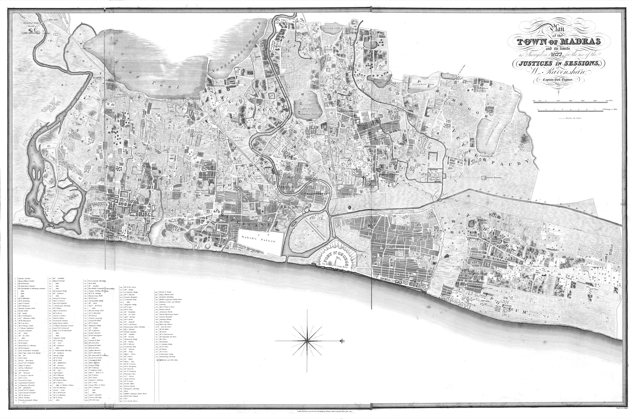
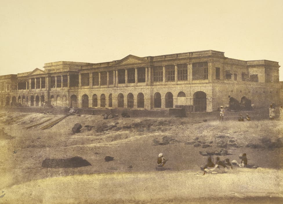
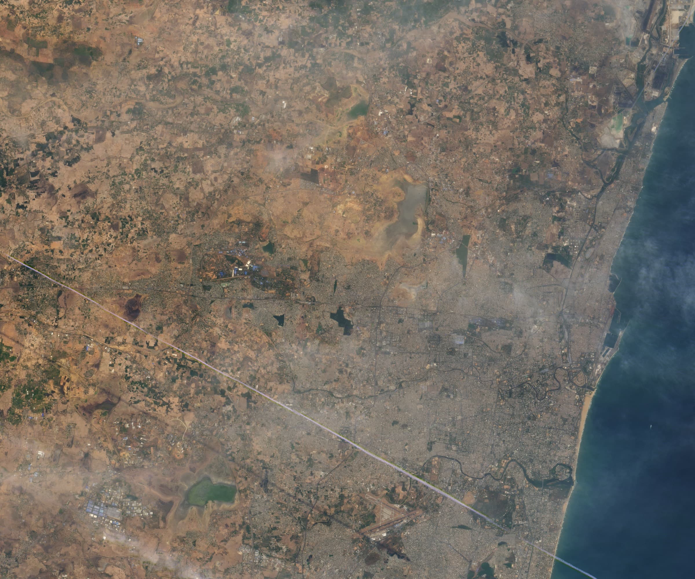
Inside the municipal boundary the same logic produced a smaller, denser cascade. The Long Tank- really two linked reservoirs, the Mylapore Tank south and the Nungambakkam Tank north, five miles long and a mile wide at peak - defined the city's western limit until 1921. Its overflow drained east through the Mambalam canal into the Adyar. The Spur Tank at Chetpet, Vyasarpadi tank (into which water from twenty-eight smaller tanks once flowed), the Mylapore tank, the Perambur and Peravallur and Madavakkam tanks, the Chetput and Kottur and Kalikundram tanks - all of them held water year-round and fed the wells around them. Around 1900, by S. Muthiah's reading of the Madras municipal records in Madras Rediscovered, there were something like three hundred water bodies inside the city. The eri network was not folklore. It was the city's plumbing.
“About a hundred years ago, Madras had within its municipal limits something like three hundred water bodies. Today, there are hardly a couple of dozen.”
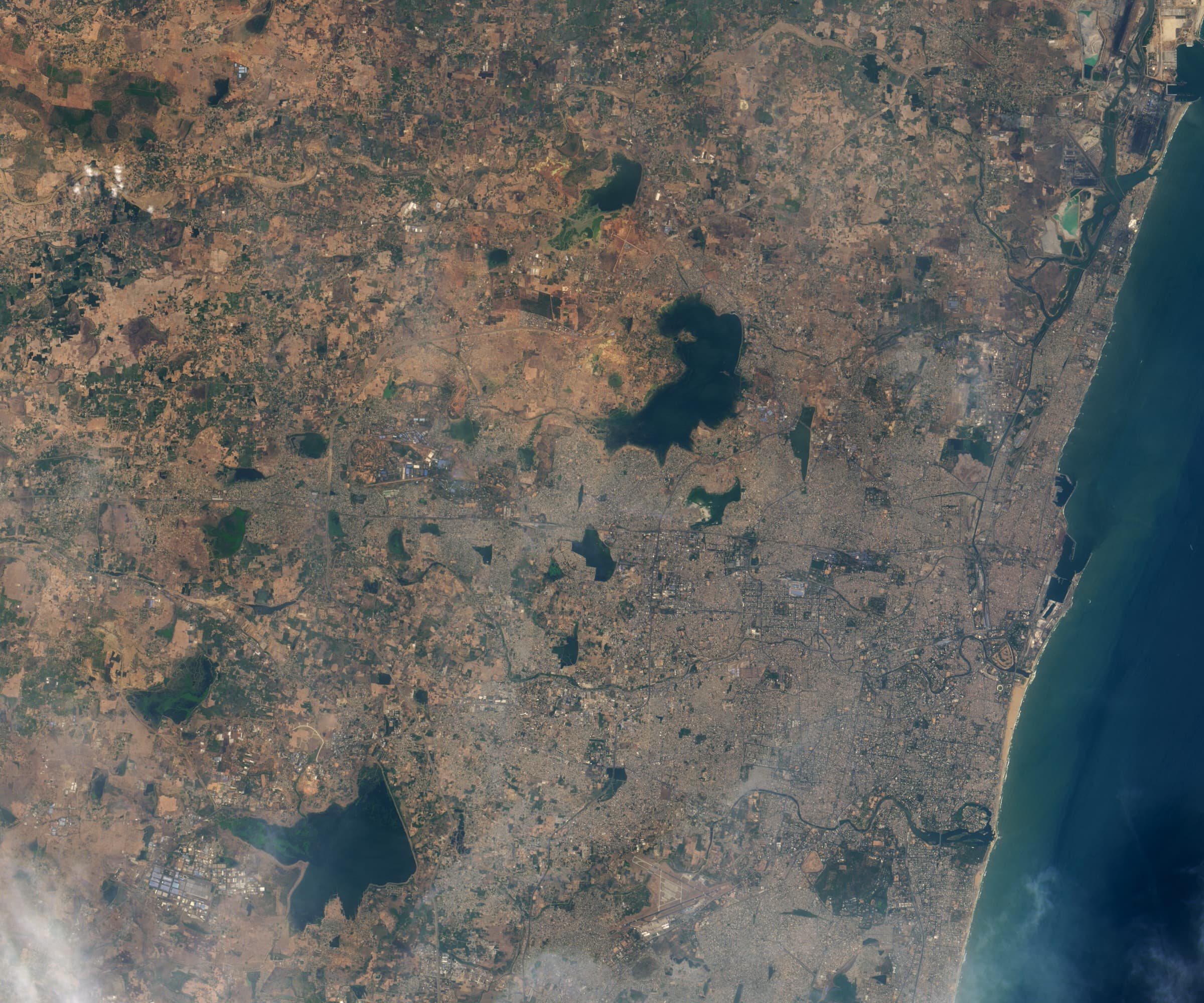
South of all this, beyond the city's boundary until the late twentieth century, lay the southern aquifer recharge - the Pallikaranai marsh. One of only two natural freshwater marshes in South India, and the only one inside any Indian metropolis, it covered roughly six thousand hectares at its mid-twentieth-century baseline. The marsh was where the city's monsoon went when it had nowhere else to go: the flat terminus of the Adyar and Buckingham basins, a sponge that swelled in November and shrank by April. It was not a wasteland. It was the bottom of a watershed.
How the cascade came undone
The cascade did not collapse from one cause. It was unwound, piece by piece, by named decisions across three eras.
The British East India Company found the eri system working. The Madras Presidency that the Crown inherited from the Company in 1858 did not. The colonial engineering office did not see a functioning hydraulic civilisation; it saw obsolete plumbing. Large dams and centralised waterworks were modern. A village-managed cascade maintained by a hereditary water-turner and an annual labour obligation was, in the colonial mind, something to be replaced. Mosse's 1999 paper Colonial and Contemporary Ideologies of ‘Community Management’ argues that the very story of decayed kudimaramathu was constructed by colonial administrators to justify state takeover. The eris did not stop working because the institution failed. The institution was first declared failed, and then starved of the authority that kept it running.
Two pieces of legislation, made in Madras itself, finished the job. The 1865 Madras Irrigation Cess Act let the colonial state collect a separate revenue on water, distinct from the land tax; the village's labour obligation to the cascade and its right to use the cascade's water were now legally separate transactions. The historian Aditya Ramesh (Studies in History, 2018) calls this the moment colonial law made the “natural” and “customary” distinction that broke kudimaramathu. The 1882 Madras Compulsory Labour Act repealed the customary obligation itself. By the end of the century, every system tank over a hundred acres had passed to the Public Works Department, which had neither the local knowledge nor the local incentive to maintain them at the cadence they needed.
Then came an engineering project that, like a knife drawn across a country, severed the cascade laterally. The Buckingham Canalbegan in 1806 as Cochrane's Canal, an eighteen-kilometre saltwater cut from North Madras to Ennore financed by Basil Cochrane. In 1877-78, during the Great Famine that killed several million people across the Madras Presidency, the eight-kilometre stretch linking the Adyar and Cooum was excavated as famine relief, at a cost of three million rupees. By the time it was renamed for the Duke of Buckingham in 1878, the canal ran 796 kilometres parallel to the Coromandel coast, from Kakinada in present-day Andhra Pradesh to Pichavaram in Tamil Nadu. It sliced laterally across the south-flowing Coromandel drainage. Tanks that had spilled into the natural slope now spilled into a fixed-level navigation channel. Some lost their downstream cascade entirely. Today the canal is largely a sewer.
After 1947, the colonial framing carried over. Every named tank inside the city limit became a piece of land waiting for an excuse.
“Valluvar Kottam stands on the Nungambakkam Tank's bed. T. Nagar stands on the Long Tank's.”
1923.The Madras Presidency, under the Madras Town Planning Act of 1920, drained the southern half of the Long Tank - the Mylapore Tank - to lay out the city's first planned neighbourhood. Theyagaraya Nagar, named for Sir Pitti Theagaraya Chetty, opened for plotting in 1923-25. The shopping district that most of urban Tamil Nadu now thinks of as the centre of Chennai is built on a drained tank. 1971.The northern half - the Nungambakkam Tank - was filled to make Valluvar Kottam, the memorial to the poet-saint Tiruvalluvar. Spur Tank at Chetpet was encroached and silted up by 1939; the name survives as Spur Tank Road. The Vyasarpadi tank, into which twenty-eight other tanks once flowed, was buried under the Tamil Nadu Housing Board's Vyasarpadi Neighbourhood Scheme and the Vyasarpadi Industrial Estate in the 1960s and 70s. Of the three hundred water bodies S. Muthiah counted within the old city limit at the turn of the twentieth century, by the late 1990s scarcely two dozen named ones remained as functional water inside that footprint - the rest had been drained, paved, or built over.
South of the city, the larger sponge went under the same way - faster.
Pallikaranai shrank from about six thousand hectares at its mid-twentieth-century baseline to roughly nine hundred by 1972, and to about 593 hectares as documented in 2016 research (Nagendran et al.). Care Earth Trust's founder Jayshree Vencatesan, whose 2014 dossier on the marsh would later become the evidentiary basis for a Madras High Court order halting further encroachment, called it a ninety per cent loss in four decades. The list of named encroachers reads like a directory of the modern city: the Perungudi dump (1970, expanded to 56 hectares by 2002 and 136 hectares by 2007, receiving roughly half of Chennai's solid waste); the Mass Rapid Transit System through the 1990s; Tidel Park, inaugurated by Prime Minister Vajpayee on 4 July 2000 on eight acres at Taramani; the National Institute of Ocean Technology; SIPCOT IT Park at Siruseri across two thousand acres; the forty-five-kilometre Old Mahabalipuram Road bisecting the cascade that fed the marsh from the north. None of these decisions were taken by accident. Each was approved, gazetted, and built by an identifiable office.
And upstream of the city, the same engineers who had built the Krishna Water inter-state agreement in 1983 and the New Veeranam Cauvery transfer in 2004 - both intended to backstop a city whose own cascade was failing - were also signing off, year after year, on the sand-mining leases that lowered the Palar and Kosasthalaiyar beds below the elevation of the channels that used to feed the upstream tanks. The Chembarambakkam reservoir filled. The eris that should have pre-loaded its catchment did not. The cascade was no longer just blocked. It was physically decoupled from the river it used to draw from.
“The cascade is not gone. It is just disconnected.”
Where we stand now
The 2015 floods and the 2019 Day Zero were the same catastrophe in different seasons. The sponge that absorbed the monsoon, and held it through summer, was gone.
Chennai's water condition is one of the better documented in the country. Chola inscriptions named the larger eris. The 1822 Ravenshaw plan and the 1834Environs of Madras survey mapped them. S. Muthiah's Madras Rediscovered compiled the lost-tank inventory. David Mosse's anthropology traced how the institutional authority unwound. Care Earth Trust's 2014 dossier identified sixty-one interconnected wetlands draining into Pallikaranai. MIDS economist S. Janakarajan's long line of work on Chennai's peri-urban water built the case for treating flood and drought as one problem. The Comptroller and Auditor General's 2017 audit of the 2015 floods documented, in the state's own language, what every household south of the Cooum already knew. What follows is a comparison between what those sources documented and what our own pipeline measures from live feeds today.
Two events frame the present. The first was the December 2015 floods. November rainfall over Chennai metro totalled 1,218 millimetres at Nungambakkam - three times the normal. On 1 December the metro mean for a single day was 286 millimetres; one IMD station recorded 494 millimetres in twenty-four hours. Chembarambakkam reservoir, already nearly full, released about thirty thousand cusecs into the Adyar over two days. The Comptroller and Auditor General would later record that the Compendium of Rules for Chembarambakkam had not been revised since 1993, that the wireless link from the dam had been non-functional for over six months, that the Water Resources Department had no real-time inflow forecast as required by Central Water Commission guidelines, and that the District Collector and police were notified only on the day the flood arrived. The official toll across Tamil Nadu was at least 289; some aggregations put the death toll inside Chennai near 500. Economic damage was estimated at around three billion US dollars (World Weather Attribution; over three million people lost basic services). IIT Madras was inundated; the semester was cut short.
The second was the morning of 19 June 2019. The 2018 northeast monsoon had delivered 343.7 millimetres of rain to Chennai - against a normal of 757.6, a fifty-five per cent deficit. By midsummer 2019, all four of the city's reservoirs had effectively gone dry. On the morning of 19 June, combined usable storage across the four was about nineteen million cubic feet (CMWSSB lake-level archive), against a combined design capacity of 11,057 million cubic feet. The city was short two hundred million litres a day. On 12 July, the first Jolarpettai water train pulled into the Villivakkam Integral Coach Factory siding: fifty wagons, two and a half million litres, drawn from a sub-basin a hundred and fifty kilometres away. Private tankers, normally selling a twelve-thousand-litre load for fifteen hundred to two thousand rupees, were charging three to five thousand. The New York Times, the BBC, CNN and Reuters all ran the story between June and August. An Indian metropolis had run out of water. Globally, that was the headline. What it actually was - the same broken sponge that had drowned the city forty-three months earlier - did not travel as well.
Sanitation has improved. Legal frameworks have improved. Specific lakes - Sembakkam, Korattur, Madambakkam, Velachery, the Adyar Creek estuary - have had bunds repaired and inflow channels cleared. Pallikaranai is a Ramsar site. The hydraulic system itself, the river-channel-tank cascade that defined this city for two thousand years, has not. The Cooum is the most polluted river in the country. Groundwater under T. Nagar - which is to say, under the bed of the drained Long Tank - is being drafted faster than it can recharge from a tank that no longer exists. The reservoirs that the city now depends on sit downstream of upstream tanks that no one in any department's plan is responsible for keeping wet. The cascade has not reconnected because no one has yet drawn the line from sand mining to bed drop to severed channel to dry eri to a thirsty reservoir to a city that, every few years, alternates between drowning and running out.
See today's live numbersWhat we owe it
The fix is not heroic. It is owed.
A city built on three hundred water bodies, of which two dozen now survive, is not a private possession. It was given to us. The Long Tank we built T. Nagar on was not ours to drain. The Pallikaranai marsh we paved with a dump and an IT park was not ours to fill. The obligation called kudimaramathu, that the people who used the cascade owed it maintenance, did not end when the colonial office stopped recording it in 1882. We just stopped paying.
“Sometimes it seems like what is on paper is more important than what is on the ground. If you are living on a piece of land that you think you own, you still have to prove on paper that you are occupying it. If what you are sailing on is water, you must have a piece of paper that says this is water.”
What restoration looks like, concretely, is not glamorous. It is a sequence of unromantic decisions, some of them already in motion:
- The Pallikaranai Ramsar designation (2022). Site #2481, gazetted area 1,247 hectares. The first formal recognition that the marsh is not waste land. Triggered by Care Earth Trust's 2014 sixty-one-wetland dossier, which became the basis for a Madras High Court order halting further encroachment in the watershed. Status: designated. Implementation of the management plan is still partial. Jayshree Vencatesan was named the first Indian recipient of the Ramsar Award for Wise Use of Wetlands in 2025.
- Tholkappia Poonga and the Adyar eco-restoration. Phase one rehabilitated fifty-eight acres of the Adyar Creek; the full plan covers three hundred and fifty-eight acres of the Creek and Estuary. Faunal species rose from 141 pre-restoration to 424 today; over 1.1 lakh students from 1,446 schools have visited the environmental education centre. Named for Tolkappiyar, the second-century BCE Tamil grammarian whose Tolkappiyam is the oldest surviving text in the language.
- The Sembakkam-Korattur cascade pilot. The Nature Conservancy India, with Care Earth and IIT Madras, restored Sembakkam (100 acres, ~100,000 cubic metres of additional storage, ~7 MLD nature-based wastewater treatment) on Cognizant and Grundfos CSR funding. The stated frame is the right one: the interconnected lakes that drain into Pallikaranai, restored as a cascade rather than as individual tanks. Care Earth's 2024 plan for Ambattur, Rettai and Korattur eris (the West Chennai cascade) does the same.
- The 2003 rainwater-harvesting mandate. Tamil Nadu government order making RWH compulsory for every building, with disconnection as the penalty. The Rain Centre, founded by Sekhar Raghavan, helped drive household compliance. In the years since, audits have found that compliance is patchy - more than forty thousand buildings still lack working systems, and only about forty per cent of installed structures are judged effective - but the mandate itself is durable.
- The 2024 Madras High Court water-body registry order. A statewide directive requiring every Tamil Nadu municipality to publish a public register of every water body, with survey number and original and present extent. Chennai is bound by it. Status: pending compliance. Until compliance happens, every encroached tank is plausibly deniable.
What is missing from every one of those plans, and what this dashboard exists to surface: the cascade itself. The eris cannot reconnect to the river system that fed them while sand-mining keeps lowering the bed of the Palar and the Kosasthalaiyar below the channels that used to draw from them. The reservoirs cannot be made drought-proof while the upstream tanks that are supposed to pre-load their catchments are silted up, encroached, or simply absent from any department's line item. A single restored lake fed only by direct rainfall is, like a temple tank without its feeder channel, a swimming pool. The work this dashboard tracks is whether, eri by eri, the cascade comes back.
Madras was built at the end of a watershed. Chennai will only be drought-proof and flood-proof when it starts behaving like one again.
See the cascade today on the mapQuotable facts and citations